By ROB COOPE PUBLISHED: 09:11 EST, 25 May 2012 | UPDATED: 12:49 EST, 25 May 2012
These remarkable 19th century sepia-tinted pictures show the American West as you have never seen it before - as it was charted for the first time.The photos, by Timothy O'Sullivan, are the first ever taken of the rocky and barren landscape. At the time federal government officials were travelling across Arizona, Nevada, Utah and the rest of the west as they sought to uncover the land's untapped natural resources.

Breathtaking landscape: A view across the Shoshone Falls, Snake River, Idaho in 1874 as it was caught on camera by photographer Timothy O'Sullivan during Lt. George M. Wheeler's survey west of the One Hundredth Meridian that lasted from 1871 to 1874. Approximately 45 feet higher than the Niagara falls of the U.S and Canada, the Shoshone Falls are sometimes called the 'Niagara of the West'. Before mass migration and industrialisation of the west, the Bannock and Shoshone Indians relied on the huge salmon stocks of the falls as a source of food. And the John C. Fremont Expedition of 1843, one of the first missions to encounter the falls reported that salmon could be caught simply by throwing a spear into the water, such was the stock

Land rising from the water: The Pyramid and Domes, a line of dome-shaped tufa rocks in Pyramid Lake, Nevada photographed in 1867. Taken as part of Clarence King's Geological Exploration of the Fortieth Parallel, O'Sullivan's mesmerising pictures of the other-wordly rock formations at Pyramid Lake committed the sacred native American Indian site to camera for the first time

Famous photographer: Timothy O'Sullivan whose childhood and background are the subject of debate among photographic scholar was of Irish ancestry. It is known that as a teenager he worked in the studio of the legendary 19th century photographer Mathew Brady, who is seen as the father of photo-journalism. A veteran of the American Civil War in its first year, O'Sullivan turned his hand to photographing the horrors of war in during the final three years of the conflict before setting out on his cross-continental expeditions.
Timothy O'Sullivan, who used a box camera, worked with the Government teams as they explored the land. He had earlier covered the U.S. Civil War and was one of the most famous photographers of the 19th century.
He also took pictures of the Native American population for the first time as a team of artists, photographers, scientists and soldiers explored the land in the 1860s and 1870s.
The images of the landscape were remarkable - because the majority of people at the time would not have known they were there or have ever had a chance to see it for themselves.
O'Sullivan died from tuberculosis at the age of 42 in 1882 - just years after the project had finished .
He carted a dark room wagon around the Wild West on horseback so that he could develop his images. He spent seven years exploring the landscape and thousands of pictures have survived from his travels.
The project was designed to attract settlers to the largely uninhabited region.
O'Sullivan used a primitive wet plate box camera which he would have to spend several minutes setting up every time he wanted to take a photograph.
He would have to assemble the device on a tripod, coat a glass plate with collodion - a flammable solution. The glass would then be put in a holder before being inserted into a camera.
After a few seconds exposure, he would rush the plate to his dark room wagon and cover it in chemicals to begin the development process.
Considered one of the forerunners to Ansel Adams, Timothy O'Sullivan is a hero to other photographers.
'Most of the photographers sent to document the West's native peoples and its geologic formations tried to make this strange new land accessible, even picturesque,' said Keith McElroy a history of photography professor in Tucson.
'Not O'Sullivan.
'At a time when Manifest Destiny demanded that Americans conquer the land, he pictured a West that was forbidding and inhospitable.
'With an almost modern sensibility, he made humans and their works insignificant.
'His photographs picture scenes, like a flimsy boat helpless against the dark shadows of Black Canyon, or explorers almost swallowed up by the crevices of Canyon de Chelly.'

Native Americans: The Pah-Ute (Paiute) Indian group, near Cedar, Utah in a picture from 1872. Government officials were chartering the land for the first time as part of Lt. George M. Wheeler's survey west of the One Hundredth Meridian which O'Sullivan accompanied the Lieutenant on. During this expedition O'Sullivan nearly drowned in the Truckee River (which runs from Lake Tahoe to Pyramid Lake, located in northwestern Nevada) when his boat got jammed against rocks.
Breathtaking: Twin buttes stand near Green River City, Wyoming, photographed in 1872 four years after settlers made the river basin their home. Green River and its distinctive twin rock formations that stand over the horizon was supposed to the site of a division point for the Union Pacific Railroad, but when the engineers arrived they were shocked to find that the area had been settled and so had to move the railroad west 12 miles to Bryan, Wyoming.
19th century housing: Members of Clarence King's Fortieth Parallel Survey team explore the land near Oreana, Nevada, in 1867. Clarence King was a 25-year-old Yale graduate, who hired Irish tough guy O'Sullivan for his Geological Exploration of the Fortieth Parallel. Funded by the War Department, the plan was to survey the unexplored territory that lay between the California Sierras and the Rockies, with a view toward finding a good place to lay railroad tracks while also looking for mining possibilities and assessing the level of Indian hostility in the area.
Incredible: Tents can be seen (bottom, centre) at a point known as Camp Beauty close to canyon walls in Canyon de Chelly National Monument, Arizona. Photographed in 1873 and situated in northeastern Arizona, the area is one of the longest continuously inhabited landscapes in North American and holds preserved ruins of early indigenous people's such as The Anasazi and Navajo.

On this rock I build a church: Old Mission Church, Zuni Pueblo, New Mexico pictured in 1873 where the Zuni people of North have lived for millennia. O'Sullivan was famous for not trying to romanticise the native American plight or way of life in his photographs and instead of asking them to wear tribal dress was happy to photograph them wearing denim jeans.

9. Native Americans: Boat crew of the 'Picture' at Diamond Creek. Photo shows photographer Timothy O'Sullivan, fourth from left, with fellow members of the Wheeler survey and Native Americans, following ascent of the Colorado River through the Black Canyon in 1871. O'Sullivans work during Lt. George M. Wheeler's survey west of the One Hundredth Meridian in Black Canyon has been called some of the greates photography of the 19th century and a clear inspiration for that other great American photographer Ansel Adams.

Landscape: Browns Park, Colorado, as seen by Timothy O'Sullivan in 1872 as he chartered the landscape for the first time. Historians have noted that even though the photographer had become a more-than-experienced explorer at this point, the ordeals of the Wheeler survey tested him to the extremes of his endurance

Rockies: A man sits on a shore beside the Colorado River in Iceberg Canyon, on the border of Mojave County, Arizona, and Clark County, Nevada in 1871 during the Wheeler expedition. Lieutenant Wheeler insisted that the team explore the Colorado River by going upstream into the Grand Canyon--apparently to beat a rival, who had first gone downriver in 1869. There was no particular scientific reason to do the trip backward.

Timothy O'Sullivan's darkroom wagon, pulled by four mules, entered the frame at the right side of the photograph, reached the center of the image, and abruptly U-turned, heading back out of the frame. Footprints leading from the wagon toward the camera reveal the photographer's path. Made at the Carson Sink in Nevada, this image of shifting sand dunes reveals the patterns of tracks recently reconfigured by the wind. The wagon's striking presence in this otherwise barren scene dramatises the pioneering experience of exploration and discovery in the wide, uncharted landscapes of the American West.

Industrial revolution: The mining town of Gold Hill, just south of Virginia City, Nevada, in 1867 was town whose prosperity was preserved by mining a rare silver ore called Comstock Lode. On the United States Geological Exploration of the Fortieth Parallel, Clarence King insisted that his men dress for dinner every evening and speak French, and O'Sullivan had no difficulty fitting in.

Early rails: A wooden balanced incline used for gold mining, at the Illinois Mine in the Pahranagat Mining District, Nevada in 1871. An ore car would ride on parallel tracks connected to a pulley wheel at the top of tracks. Because of his work in U.S Civil War of 1861 to 1865, the organisers of the two geological surveys that he photographed knew that O'Sullivan was made of stern stuff and therefore could cope with the rigurs of life outdoors far from home

Silver mining: Here photographer Timothy O'Sullivan documents the actvities of the Savage and the Gould and Curry mines in Virginia City, Nevada, in 1867 900ft underground, lit by an improvised flash -- a burning magnesium wire, O'Sullivan photographed the miners in tunnels, shafts, and lifts. During the winter of 1867-68, in Virginia City, Nevada, he took the first underground mining pictures in America. Deep in mines where temperatures reached 130 degrees, O'Sullivan took pictures by the light of magnesium wire in difficult circumstances
Untouched landscape: The head of Canyon de Chelly, looking past walls that rise some 1,200 feet above the canyon floor, in Arizona in 1873
Barren: Two men sit looking at headlands north of the Colorado River Plateau in 1872

Portrait: Native American (Paiute) men, women and children pose for a picture near a tree. The picture is thought to have been taken in Cottonwood Springs (Washoe County), Nevada, in 1875

Natural U.S. landscape: The junction of Green and Yampah Canyons, in Utah, in 1872

An earlier visitor: Nearly 150 years ago, photographer O'Sullivan came across this evidence of a visitor to the West that preceded his own expedition by another 150 years - A Spanish inscription from 1726. This close-up view of the inscription carved in the sandstone at Inscription Rock (El Morro National Monument), New Mexico reads, in English: "By this place passed Ensign Don Joseph de Payba Basconzelos, in the year in which he held the Council of the Kingdom at his expense, on the 18th of February, in the year 1726"
Insight: Aboriginal life among the Navajo Indians. Near old Fort Defiance, New Mexico, in 1873

Incredible backdrop: The Canyon of Lodore, Colorado, in 1872

Settlement: View of the White House, Ancestral Pueblo Native American (Anasazi) ruins in Canyon de Chelly, Arizona, in 1873. The cliff dwellings were built by the Anasazi more than 500 years earlier. At the bottom, men stand and pose on cliff dwellings in a niche and on ruins on the canyon floor. Climbing ropes connect the groups of men.

Sailing away: The Nettie, an expedition boat on the Truckee River, western Nevada, in 1867

Taking a dip: A man bathing in Pagosa Hot Spring, Colorado, in 1874

A man sits in a wooden boat with a mast on the edge of the Colorado River in the Black Canyon, Mojave County, Arizona. At this time, photographer Timothy O'Sullivan was working as a military photographer, for Lt. George Montague Wheeler's U.S. Geographical Surveys West of the One Hundredth Meridian. Photo taken in 1871, from an expedition camp, looking upstream
Native: Maiman, a Mojave Indian, guide and interpreter during a portion of the season in the Colorado country, in 1871

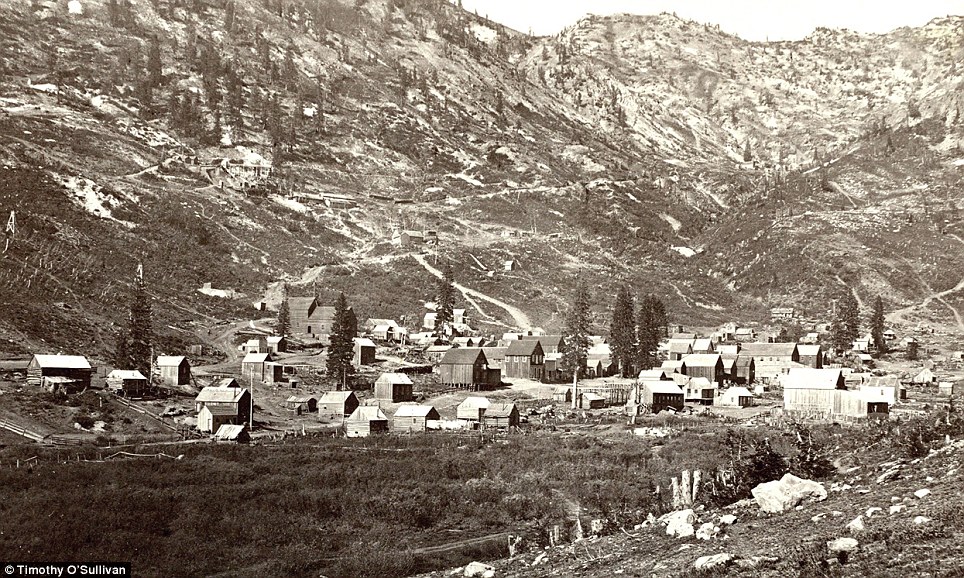
Valley view: Alta City, Little Cottonwood, Utah, in 1873

Remarkable landscape: Cathedral Mesa, Colorado River, Arizona in 1871
Mountains: Big Cottonwood Canyon, Utah, in 1869. A man can be seen with his horse at the bottom near the bridge (right)

Rock formations in the Washakie Badlands, Wyoming, in 1872. A survey member stands at lower right for scale

Tree-mendous: Oak Grove, White Mountains, Sierra Blanca, Arizona in 1873
Shoshone Falls, Idaho near present-day Twin Falls, Idaho, is 212 feet high, and flows over a rim 1,000 feet wide. it is pictured in 1868
Rocky: The south side of Inscription Rock (now El Morro National Monument), in New Mexico in 1873. The prominent feature stands near a small pool of water, and has been a resting place for travellers for centuries. Since at least the 17th century, natives, Europeans, and later American pioneers carved names and messages into the rock face as they paused. In 1906, a law was passed, prohibiting further carving.

Very plain landscape: A distant view of Santa Fe, New Mexico in 1873